|
||||


|
Updated: September 6, 2001 |
|
|
|||||||||||||||||||||||||||||||||||||||||||||||||||||||||||||||||||||||||||||||||||||
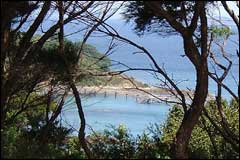 Many people use the waters around Tiritiri Matangi for fishing and diving |
|
|
Tiritiri Matangi is a small island at the entrance to Waitemata Harbour. It belongs to the Inner Gulf Ecological District and became a Scientific Reserve in 1980. The island is managed by DoC as an open sanctuary that hosts over 20,000 visitors per year.
Tiritiri Matangi is located 5 km to the east of the Whangaparaoa Peninsula. It has a land area of 220 ha and is just over 2.5 km in length and 1km wide. The island has rolling hills with steep cliffs on the northern coast as a result of coastal erosion. There is a flat-topped ridge in the centre of the island.
Tiritiri Matangi's exposed position in the Gulf makes it vulnerable to winds from all directions. It catches the prevailing southwesterly wind and the weather from the northeast is wet and often stormy. Early Maori recognised this and named the island Tiritiri Matangi meaning "tossed by the wind".
Tiritiri Matangi is subject to two high and two low tides per day with tide levels changing between 1.8m and 2.4m. Unlike the outer Gulf's clear water the inner Gulf often has sand and mud suspended in the water making it quite murky. Visibility in the water around Tiritiri Matangi ranges from 5 to 9 metres.