|
|||
|
||||
|
Updated: September 6, 2001 |
|
|
|||||||||||||||||||||||||||||||||||||||||||||||||||||||||||||||||||||||||||||||||||||
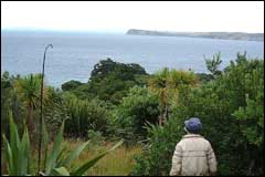
 Tiritiri Matangi has a flat-topped central ridge, viewed here from the southern side |
|
|
Tiritiri Matangi Island is a remnant of the Whangaparoa peninsula and now lies 4km from the end of the peninsula separated by the inner waters of the Hauraki Gulf.
The greywacke rocks of this peninsula, were uplifted around 20 million years ago. Most of the Waitemata conglomerate rocks have been eroded from Tiritiri Matangi since the basin was uplifted. You can only see them on the northwest end of the island as the rocky outcrops along the shoreline.
These greywackes are mainly deposits of Gondwanaland mud and sand formed under the sea between 270 and 150 million years ago. As they were compressed, fractured and folded with the movement of the tectonic Australian and Pacific plates in higher temperatures and pressures they were buried beneath many kilometres of rock.
At present Tiritiri Matangi has a prominent flat-topped central ridge. The northern coast is exposed to the sea and has formed steep cliffs and shore platforms where the sea has cut into the land.