Learnz 2001

Click for Great Barrier Island homepage

Background

Great Barrier homepage 


An Island Environment

Biodiversity

Geology and landforms

Outer Hauraki Gulf

Offshore islands

Wetlands


People and the Environment

Cats

Conservation

Meet DoC's Rebecca Stanley

European settlements

Goats

Kauri - a natural resource

Maori history

Minerals and mining

Shipwrecks

Weeds and plant pests

Whaling


Threatened Species

Black petrel pics

Black petrel facts

Brown teal pics

Brown teal facts

Chevron skink pics

Chevron skink facts

Kauri

Kereru

What is a lizard?

Geckos

Skinks

North Island kaka

Endangered plants

Updated: September 12, 2001


New Zealand and its Offshore Islands

New Zealand is a country in the southwest Pacific Ocean. It has two main islands and many smaller ones. (See map, below). The total land area is 270,500 sq km and is similar in size to Japan or the British Isles.

Land Areas of New Zealand

Land area

Size

North Island

113 729 sq km

South Island

150 437 sq km

Stewart Island

1 065 sq km

Chatham Islands

963 sq km

Raoul Island

34 sq km

Campbell Island

113 sq km

Great Barrier Island

285 sq km

Tiritiri Matangi

2.2 sq km

All other islands over 20 sq km

1 065 sq km

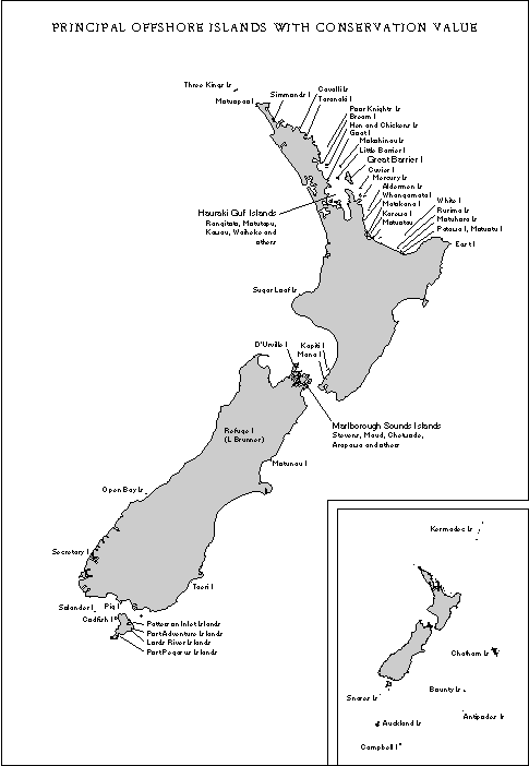
Some Offshore Islands by Region

Region

Islands

Northland

Poor Knights

Hen and Chicken

Three Kings

Auckland

Kermadec

Great Barrier

Tiritiri Matangi

Waikato

Mercury

Curvier

Alderman

Bay of Plenty

Whale

White

Motiti

Mayor

Wellington

Mana

Kapiti

Somes/Matiu

Nelson

Stephens

Chetwode

Maud

Titi

The Brothers

West Coast

Open Bay

Canterbury

Chatham

Southland

Snares

Bounty

Antipodes

Auckland

Campbell


Map showing New Zealand's offshore islands - Image: DoC

Print friendly page