|
|||
|
||||
|
Updated: September 12, 2001 |
|
|
|||||||||||||||||||||||||||||||||||||||||||||||||||||||||||||||||||||||||||||||
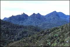 Mt Hirakimata is the highest peak on Great Barrier Island |
|
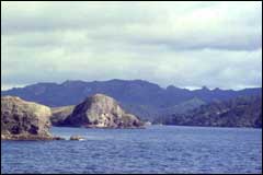 The steep hillsides of the western coast of Great Barrier Island at Port Abercrombie |
Great Barrier Island is mainly volcanic in origin. The movement of the two tectonic plates on which New Zealand sits has in the past allowed molten rock (magma) to seep up through cracks in the basement greywacke to the surface. The magma has created large volcanic dikes. This volcanic phase lasted for over 25 million years.
Around 18 million years ago a period of volcanic activity took place. Rocks formed around the coastline and on the central and southern parts of Great Barrier Island. The new rocks covered most of the existing greywacke that formed the island.
The central parts of the island are formed of younger volcanic rock that erupted 3 - 10 million years ago.
Great Barrier Island is similar in topography to the Coromandel Peninsula. It has a similar north-south running range of mountains with rocky mountain tops in the centre of the island. The central area has highest peak on Great Barrier Island - Mt Hirakimata (621m).
The east coast is made up of a number of sandy bays and river estuaries with the western coast featuring drowned river valleys and steep forest covered hillsides.
Over the past 2 million years glaciers have come and gone and the sea level has risen and fallen many times. Great Barrier Island was once linked to the Coromandel Peninsula when the sea level was lower. It has probably been an island for the past 10 000 years. This most glacial period has eroded the hillsides making the rivers valleys deeper. As the sea rose it flooded the valleys making islands out of mountain tops.