The first maps were
probably sketches in the dirt. A small clay tablet 4000
years old is the oldest known map, and it shows a river
valley in Mesopotamia (now Iraq). Polynesians made charts of
their region using woven palm fibers to show the wave
patterns of the Pacific Ocean. Sea shells marked the
location of islands. Eskimos carved their coastal features
on pieces of driftwood. Even from earliest times, people
realized that a picture was worth a thousand words.
(back to
top)
Who knew the Earth
was round and when did they know it?
People knew the Earth was round 2500 years ago. They just forgot!
Because people on earth could only see a small section of the globe at a time, it wasn't possible to tell from just looking whether the Earth was a flat disk or a round sphere. The Greeks were the first to think that the Earth was round. They thought this because of the way the altitudes of stars changed at different places on Earth, and how ships appeared on the horizon.
As a ship returned to port, first its mast tops, then the sails, and finally its hull gradually came into view. Aristotle, who lived 300 years before Christ, observed that the Earth cast a round shadow on the moon. When a light is shined on a sphere, it casts the same shadow. The Greeks calculated the general size and shape of the Earth. They also created the grid system of latitude and longitude, so that with just two coordinates one can locate any point on the Earth. (back to top)
So how come people forgot, and thought it was flat?
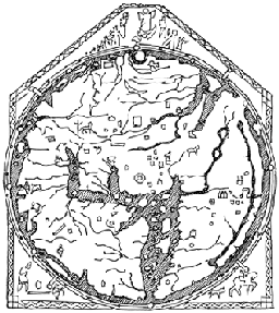
Unfortunately, learning and intellect went out of fashion in Europe between 400 and 1200 AD, and there were few scientists. Greek knowledge was lost to Western society and there began a gloomy period known as the Dark Ages. People were very ignorant and superstitious. They believed that huge sea monsters and Vikings ruled the seas, and ships that went too far from shore were sure to fall off the edge of a flat Earth. Maps made in that time were based on religious beliefs or superstitions, not on observations, calculations, or scientific inquiry. Rectangular maps of the Earth represented the "four corners of the Earth." Circular maps usually placed the birthplace of Christianity, the holy city of Jerusalem, at the center of the world. (back to top)
The Age of Discovery meant they decided it was round again!
After 1250, map making in Europe took a turn for the better. People started to travel more, and maps began to be based on observations and measurements again.
In the meantime, the Arab world had always known that the world was round, because they kept the books and findings of the Greeks, instead of deciding they were the work of the devil. At this stage, people in Europe rediscovered the Greek information and translated it so that educated Europeans could read it. The Greek methods of showing a round sphere on a flat piece of paper allowed cartographers and explorers to chart newly-discovered lands and seas. The invention of the printing press made it possible for more people to use, and improve maps.
Christopher Columbus' voyage in 1492 confirmed that the Earth was round. Magellan's crew proved the fact definitively by circling the globe on a three-year voyage from 1519-1522. (back to top)
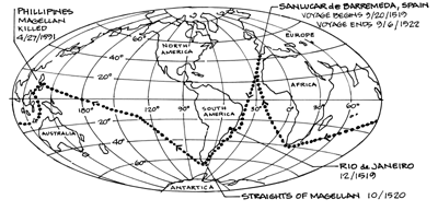
Magellan's voyage round the earth
Ferdinand Magellan (c.1480-1521) was a Portuguese sea captain who set off to find a new route to the Spice Islands, north of Australia. Magellan is remembered as leading the first expedition to circumnavigate the globe, but he didn't live to complete his journey. After weathering storms, several mutinies, fighting between Portuguese and Spanish crew members, and near starvation when they were forced to eat rats, ox hides, and sawdust, they landed in the Philippine Islands. Although they were welcomed there by the natives, Magellan became involved in local politics and was killed in a battle between two groups of Filipinos on Mactan Island.
Magellan discovered the passage between the Atlantic and the Pacific Oceans at the tip of South America, which became known as the Straits of Magellan. As he passed through the straits, he and his crew became the first Europeans to sail into the "new" ocean. Magellan named it Pacific (which means peaceful) because it appeared calm after the stormy Atlantic. In reality, the Straits of Magellan and the Pacific Ocean are noted for their high winds, giant waves, and violent weather.
It took Magellan's crew three years to complete their voyage, while today it takes a satellite about 100 minutes to circumnavigate the globe. (back to top)