|
|
|
|
Street maps are too small to show latitude and longitude. They use grid lines. Here are street maps of the area around Puhinui School. They come from a website at www.nzmaps.co.nz, and the maps are supplied by Terralink NZ Limited, Wellington. Rory Fogerty is the webmaster who gave permission for us to use them on our intranet.
Do you think it is useful to have maps like this available on the internet? You could email him at rory@ownworld.com and tell him why you think they are a good idea.
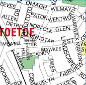 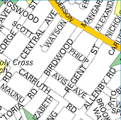 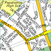 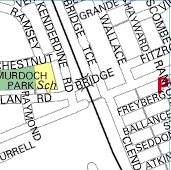 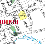 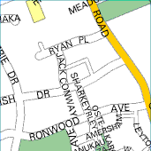 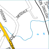  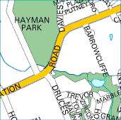 |
How good are your map-reading skills? Plan a route to get from Puhinui School to Papatoetoe High School. Start from Puhinui School, turn left down Puhinui Rd, turn right into Wallace Rd, right into Fairview, left up Landscape, right along George St, and left into Carruth Rd. What school have you arrived at? Start at Hayman Park, go into Wiri Station Rd, turn left along Davies Ave, right into Amersham, left into Ronwood, right along Sharkey, left along Cavendish passing four roads going off on your right. What is on your right now? Name five roads that cross the Puhinui Stream in this map. Check out the answers below, and see if you were right! No cheating! |
|
Maps like this always have North at the top of the page, so you can work out which way up to hold the book. Some people can read maps holding the book any way at all. Others find it more helpful to turn the page until the roads are lined up with the way they are when you are looking at them. Which do you prefer? |
|
Are you ready to look at the answers? Make sure you have tried all of them before checking whether or not you got them correct! |
1. - many different routes are possible.
2. - you end up at Holy Cross School.
3. - Puhinui Park is on your right.
4. - Roscommon, Plunket, Ronwood, Lambie, and Wiri Station
Road.